
From snow-covered peaks to scorching outback heat, the country’s first week of summer showcases extreme climate diversity as heatwaves and severe storms create dramatic weather contrasts
Australia has experienced one of its most dramatic temperature ranges on record during the opening week of summer, with a staggering 50-degree Celsius spread between the nation’s coldest and hottest locations, highlighting the country’s extraordinary climate diversity and the increasingly volatile weather patterns affecting the continent.
The first week of the 2025-26 summer season, which began on December 1, saw temperatures plummet to minus 4.0°C at Thredbo in the New South Wales Snowy Mountains on December 2, while just four days later, thermometers soared to a blistering 46°C at both Moomba in South Australia and Birdsville in Queensland on December 6.
This remarkable 50-degree temperature spread illustrates the extremes Australians face during the transitional summer period, when two contrasting air masses jostle for dominance across the vast continent.
Summer Begins With Unseasonable Cold Snap
The season’s start brought an unexpected wintry punch to southeastern states, with cold air originating from the Southern Ocean sweeping across New South Wales, Victoria and Tasmania. Snow settled across alpine regions in all three states during the opening days of summer, with temperatures dropping below minus 2°C in multiple locations.
Mount Perisher in New South Wales received a fresh blanket of snow on December 1, while Liawanee in Tasmania recorded minus 3.5°C on the same day. Mount Hotham in Victoria wasn’t far behind, registering minus 2.8°C on December 2. The unseasonably cold conditions created surreal scenes of snow-covered peaks at the height of what should have been the beginning of Australia’s warmest season.
Scorching Heat Follows Cold Front
As the cold air retreated, a massive pool of hot air rapidly spread across the continent’s interior and western regions, bringing severe to extreme heatwave conditions. The Bureau of Meteorology issued multiple heatwave warnings for Western Australia, South Australia, the Northern Territory and Queensland, with conditions expected to persist through Friday.
Western Australia bore the brunt of the extreme heat, with a severe heatwave warning issued for the Kimberley, Pilbara, Gascoyne, North Interior and South Interior forecast districts. Maximum temperatures ranging from the high thirties to the mid-forties, combined with overnight minimums in the mid to high twenties, created dangerous conditions particularly for outdoor workers and vulnerable populations.
The Bureau warned that severe heatwave conditions would contract slowly southwards and ease over the coming days, but not before posing significant risks to anyone working or exercising outdoors, even healthy individuals.
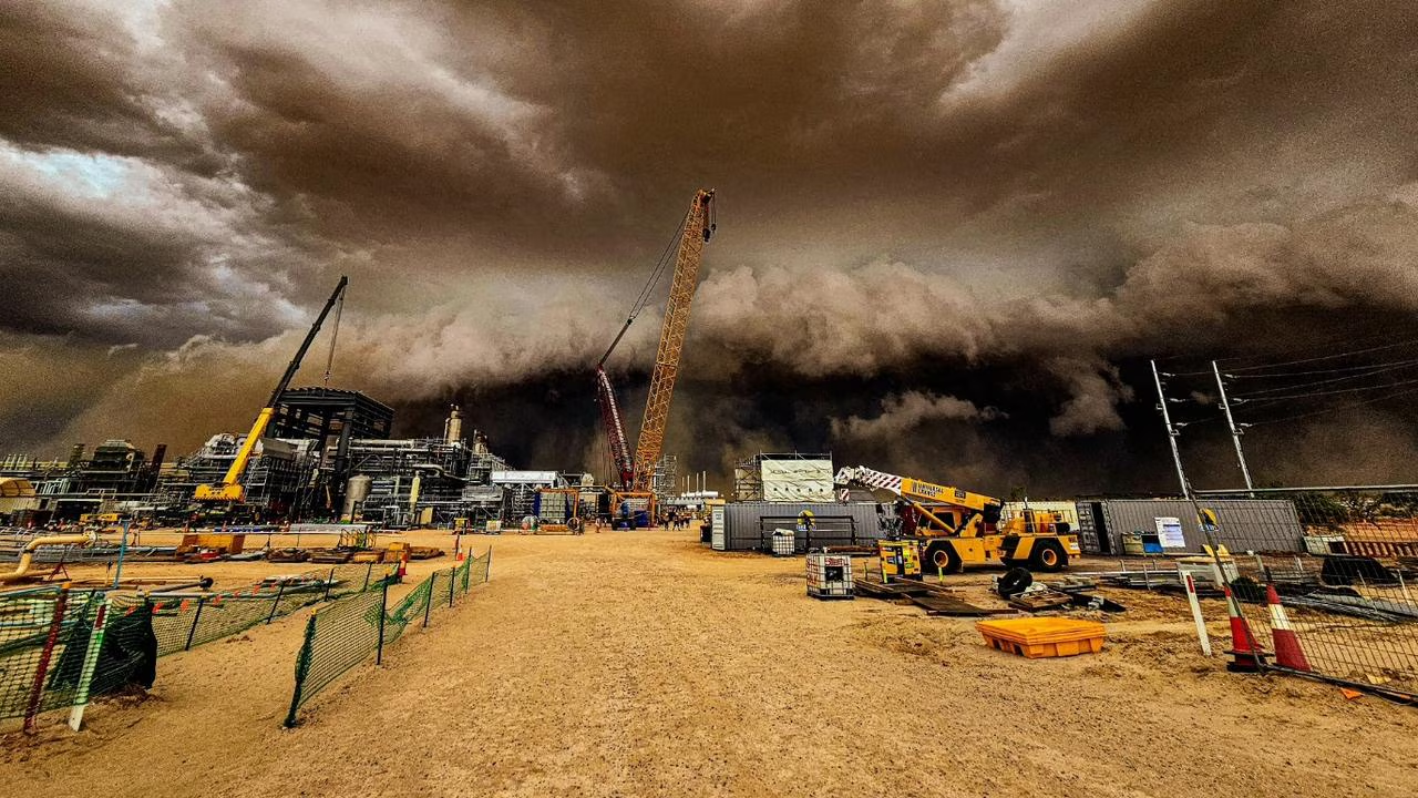
NSW Faces Hot and Stormy Conditions
While western regions battled extreme heat, New South Wales found itself dealing with a different set of challenges as hot, humid conditions combined with severe thunderstorm activity. Christie Johnson from the Bureau of Meteorology warned residents to prepare for conditions that would be “hot and stormy” as a low-pressure system moved through the state’s east.
“We are seeing a low-pressure trough moving very slowly up the coast, that’s going to trigger thunderstorms across much of northern and eastern New South Wales,” Johnson explained during a Bureau update. The system is expected to bring the risk of damaging winds, large hail and heavy rainfall that could lead to flash flooding across affected areas.
Temperatures in Sydney climbed to 30°C on Tuesday, while western suburbs like Penrith reached 39°C, representing temperatures 4 to 10 degrees above the December average. The heat combined with moisture-laden winds from the east and northeast, carrying air from the Tasman and Coral Seas, has created conditions ripe for severe weather.
Multiple Days of Rainfall Expected
Two low-pressure troughs will linger over the NSW region during the next several days, with meteorologists predicting abundant cloud, rainfall and thunderstorms across a broad area extending into the ACT and parts of Queensland and Victoria.
More than half of New South Wales is expected to receive between 10 and 30 millimetres of rain between now and Saturday, with heavier totals likely in parts of central and northern inland NSW and along the coast. Some areas could see accumulated falls exceeding 50 millimetres, with forecasts suggesting that Sydney’s Illawarra region or the metropolitan area itself could receive between 50 and 100 millimetres during Thursday and Friday.
The Bureau emphasised that the position and strength of the coastal trough remains somewhat uncertain, making precise rainfall predictions difficult. Residents across NSW have been urged to monitor the latest forecasts and radar imagery closely, with severe weather and thunderstorm warnings likely to be issued as conditions develop.
Fire Danger Remains Elevated Despite Rain
Despite the wet weather affecting coastal regions, fire danger remains elevated across much of NSW due to the preceding heat and dry conditions. While officials noted that widespread extreme fire danger was not expected, high fire danger ratings persist through much of the state.
“We’re not expecting to see the widespread extreme fire danger that we saw at the weekend,” Johnson said. “The winds are not as strong as they were on Saturday, but we are still looking at high fire danger through much of the state.”
Australia’s fire agencies have advised that there is an increased risk of fire for parts of Victoria, western and southern Western Australia, and parts of central northern New South Wales, despite the approaching wet weather.
Climate Patterns Contributing to Extremes
The extreme weather patterns affecting Australia are occurring against a backdrop of broader climate influences. The Indian Ocean Dipole is expected to return to neutral conditions in December, while conditions in the tropical Pacific indicate a relatively weak La Niña event is underway, though this is expected to be short-lived.
Sea surface temperatures in the Australian region have been the warmest or second warmest on record for each month since July 2024. Global sea surface temperatures also remain substantially above average, with October 2025 recording the third warmest temperatures on record globally.
These elevated ocean temperatures are contributing to warmer than average conditions across much of Australia, with the Bureau’s long-range forecast indicating that summer days and nights are likely to be warmer than average across most of the continent.
Record Temperature Variability
The 50-degree temperature range recorded during the first week of summer demonstrates the remarkable climate variability that characterises the Australian continent. As the world’s sixth-largest country by land area, Australia encompasses everything from tropical rainforests in the far north to alpine regions in the southeast, temperate coastlines, and one of the driest desert interiors on Earth.
The diverse geography, combined with the influence of surrounding oceans and atmospheric systems, creates conditions where snow can fall in Tasmania while temperatures simultaneously exceed 45°C in central Australia—all within the same 24-hour period.
Looking Ahead
Authorities are urging Australians to remain weather-aware and prepared for rapidly changing conditions. Between October and April, Australia experiences its peak time for severe thunderstorms, tropical cyclones, flooding, heatwaves and bushfires, making this period the most dangerous for extreme weather events.
The Northern Australian wet season is currently underway, where widespread rainfall becomes more likely and can lead to flooding in northern regions. Meanwhile, southern areas face the ongoing risk of heatwaves and bushfire conditions, particularly in regions that experienced below-average spring rainfall.
For residents across NSW and other affected states, the message is clear: monitor forecasts closely, follow all severe weather warnings, stay hydrated during hot conditions, and be prepared to adjust plans as weather systems continue to evolve throughout the summer period.
The Bureau of Meteorology continues to provide regular updates through its website and BOM Weather app, with severe weather and thunderstorm warnings issued as conditions warrant.